


Sahalee Way: The Never-Ending Study
Three expensive alternatives under consideration do NOTHING to improve vehicular traffic or increase public transit

Sahalee Way is a lifeline for many Sammamish residents, including me. For years, I've been observing an endless cycle of studies by consultants, all at taxpayer expense. After nearly $1 million spent on consultants to study options for Sahalee Way, we face a bigger question that should concern all Sammamish residents and not just those who use Sahalee Way.
As we are hurtling towards a budget deficit by 2029, should the City of Sammamish be spending anywhere from $23 million to $110 million on a road project with:
ZERO improvements for vehicular traffic and public transit
ZERO improvements on Sahalee Way from 37th Way down to Route 202
What the study studied, and what it cost
It's important to understand what these alternatives propose. The sobering reality is that all three alternatives:
Focus exclusively on non-vehicular improvement: pedestrian crossings, bicycle facilities, and sidewalk enhancements.
None of the alternatives includes improvements for public transportation or bus service.
No improvements from 37th Way (entrance to Timberline) to Route 202 (half the road is outside of Sammamish’s jurisdiction).
The alternatives break down as follows:
Alternative A
$23-28 million cost
Pedestrian crossings at potential future transit stops, plus safety and pedestrian improvements within existing sidewalk segments
Alternative B
$38-43 million cost
Corridor-wide pedestrian improvements with bicycle accommodation using continuous sidewalks and narrow shoulders
Alternative C
$100-110 million cost
Full multi-modal transformation with shared-use paths and multiple roundabouts for speed control
Below is a slide from the study session presented to City Council on June 10, 2025:
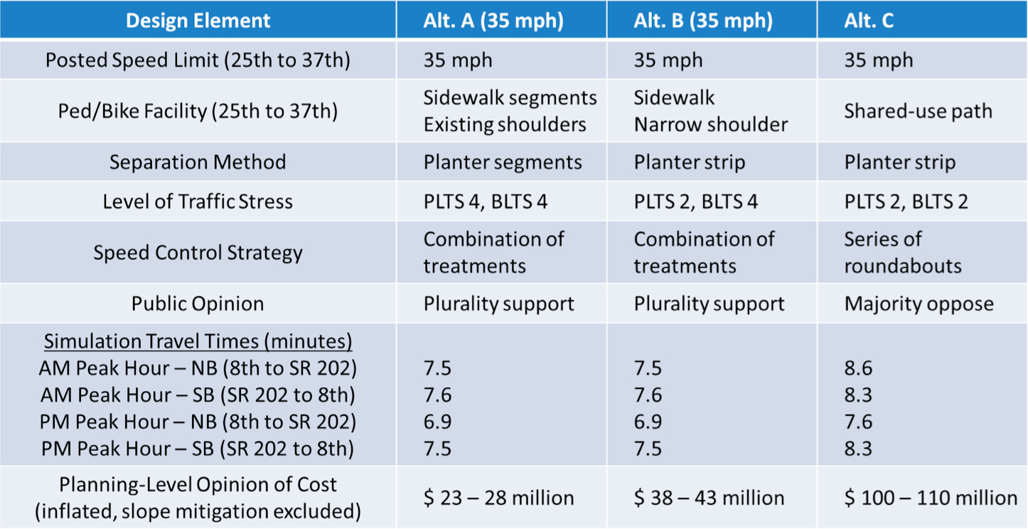
All three alternatives include lowering the speed limit to 35 mph from the current 45 mph, which would add an estimated 45 seconds to travel time in each direction during peak hours.
The travel time simulations show that all three alternatives perform nearly identically for vehicle traffic:
Alternative A takes 7.5 minutes during AM peak hours
Alternative C takes 8.6 minutes during AM peak hours
The city is debating whether to spend an extra $70 million for improvements that add 1.1 minutes to vehicle travel time and only focus on non-automotive transportation modes.
The cost of this study, awarded to Perteet in 2024, is $923,574. From my understanding, additional studies, consulting, and design work are not included in this contract.
Route 202 will remain a bottleneck
For the vast majority of Sammamish residents who use Sahalee Way in their cars, the fundamental challenge remains unchanged: these improvements will do NOTHING to relieve the congestion found at the bottom of Sahalee Way and Route 202.
This means that regardless of which alternative is selected, the daily experience for vehicle commuters dependent on traveling on Route 202 will remain frustrating. The $15-20 million in additional slope stabilization costs identified in the geotechnical studies don’t increase vehicular capacity or improvements to traffic flow.
What’s next?
At the conclusion of the June 10th study session, city staff recommended Alternative B “plus” - the middle option that focuses on pedestrian and bicycle improvements, with the “plus” being adding the “option of utilizing traffic calming measures" – measures designed to slow vehicular traffic rather than improve its flow. This will undoubtedly require an additional study before a final alternative is selected and the next phases can begin. Each phase will require its unique analysis (more studies!) and consulting (more contracts!).
30% design
Environmental review
Final design
Separate bid packages
Phased implementation
Sahalee Way NE Closure
While I was writing this article, I also received in the mail a notice from King County that both directions of Sahalee Way NE between NE 50th Street and NE 37th Way will be closed between June 28 - July 2, 2025.
Their notice highlights the sensitive and precarious nature of the deeply sloped Sahalee Way NE: “Crews will replace one drainpipe and fix another under Sahalee Way NE. Both pipes are very old and could break soon. If that happens, water could spill out and wash away the road.”
For further information and a detour map, please visit: kingcounty.gov/sahalee-way-ne
For further information on the Sahalee Way corridor study, please see:
Sahalee Way Corridor Improvements